
@iau-wgsn.bsky.social
BlueSky - our IAU edu infos
Please Contact Us
Channel
@iau-wgsn.bsky.social
BlueSky - our IAU edu infos
Please Contact Us
Channel
In ancient times, scholars used observations of lunar eclipses to obtain knowledge about our planet and its environment. With sophisticated arguments, they derived:
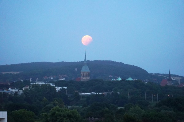
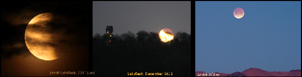
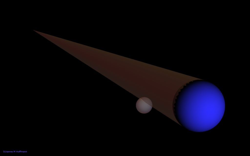
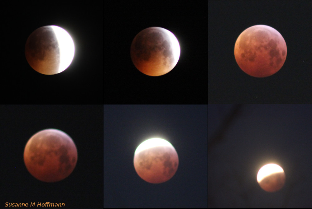
During a total lunar eclipse, the moon enters the shadow of the earth so that direct sunlight can no longer reach it, but only the light that is refracted towards it by the earth’s atmosphere. For the observer on Earth, the satellite therefore appears reddish in the sky (blue parts of the sunlight are scattered and only the low-energy red part reaches the moon). The Earth’s shadow does not have a sharp edge, of course, but it is a roughly cone-shaped area of space that lies ‘behind the Earth’ opposite the Sun.
A lunar eclipse therefore takes place in space and is independent of the location on Earth where we are observing it: The satellite physically enters this area of space. A lunar eclipse is therefore an absolute event (and not a relative one). What is relative, however, is the appearance of the phenomenon: for an observer on earth, the red moon is exactly in the south, for another it is just rising, for a third it is just setting… and for an observer on the moon, the sun disappears behind the earth: he looks at the dark side of the earth, which is surrounded by a red-golden glow (the sunlight refracted in its atmosphere).

Even in ancient times, more than 2000 years ago, people wanted to measure the earth. It had long been known that the earth was a sphere. Why? Because of the observation of lunar eclipses: they can occur at any time of night – in the evening, at midnight or in the morning – and always look the same. During the partial phase, the moon is cut by the Earth’s shadow and the light-shadow boundary on the moon is always a circle.
So if the earth always casts a circular shadow, regardless of the direction from which it is illuminated by the sun, then the shape of the earth must be a sphere. If the Earth were a cylinder (or a very flat cylinder, i.e. a disc), then its shadow would be a (thin) line/ stripe/ band at sunrise and sunset and certainly not a circle. We should therefore not be able to observe any MoFi in the evening sky: Just like yesterday evening, that the partially eclipsed moon rises and already shows a semi-circular Earth shadow – something like that would then not work.
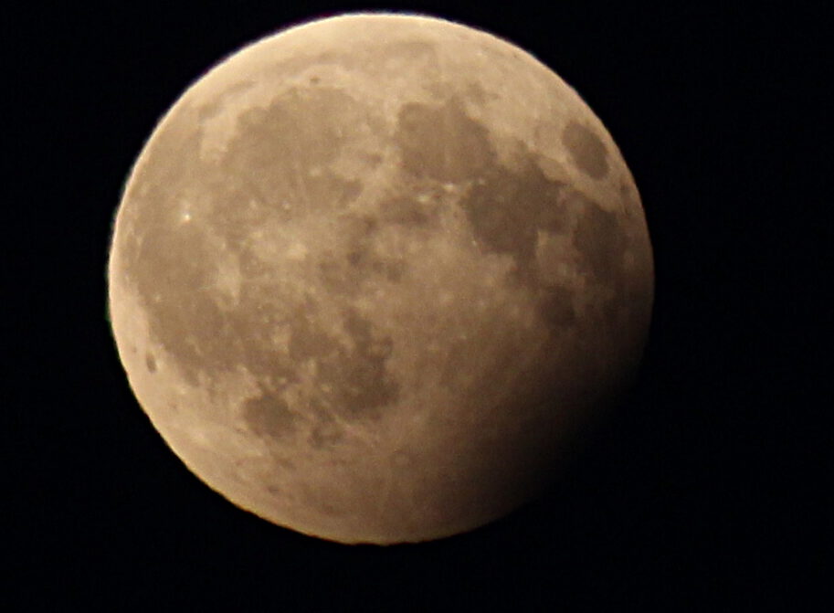
Determine the size of the moon using this one photo of the partial phase of a cloudy lunar eclipse.
Hint: Think about how a lunar eclipse works. What exactly happens during a MoFi, why is the moon eclipsed – in other words, what causes it? What is the relationship between the earth, sun and moon?
What do we see here in the picture? The solution to the problem must be related to the light-dark edge that can be seen here in the image (and not otherwise).

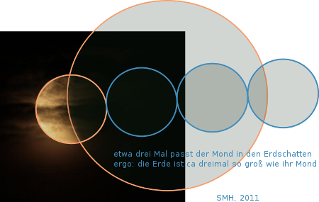
During a lunar eclipse, the moon passes through the shadow of the earth. The Earth’s shadow is approximately the same size as the Earth itself, tapering only slightly with increasing distance, as can be measured using the shadow of a tree, for example.
The light-dark edge here in the picture is therefore the boundary of the Earth’s shadow. We see here a piece of a circular arc that is sufficiently large that we can extrapolate the entire circle from it.
The modern approach is to use image processing software and draw the circle in the photo that best fits the arc. Then orbit the moon itself and copy the moon circle along the diameter of the earth’s shadow circle.
If you want to know more precisely how big the error is that we are making here because the Earth’s shadow is smaller than the Earth at the distance of the moon, then measure different shadow sizes of balls on a wall as a function of the distance between the ball and the wall! 🙂
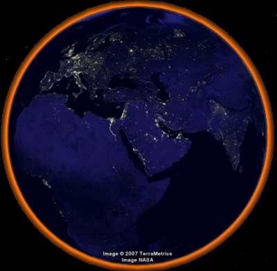
Two observers see the lunar eclipse from different positions on their horizon. For one observer it is to the west, for the other to the east. As the moment at which the edge of the shadow touches the edge of the moon is an absolute event, i.e. it occurs independently of the observer in space, time differences measured by observers must be at the observer’s position on Earth.
For every observer on Earth, ‘noon’ (their local time) is by definition exactly when the sun is in the south. We have virtually forgotten this, as nowadays we have divided the earth into time zones and wristwatches or mobile phones do not display the local time, but the time of the time zone (i.e. all watches in Germany display the time of Görlitz, regardless of whether you are in Munich, Cologne or Berlin, whereby the local time for the three cities mentioned deviates from this to varying degrees: in Berlin it is only 4 minutes, in Cologne it is almost half an hour). However, ancient observers knew this and navigators can make use of it.
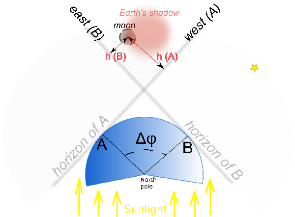
In the diagram, observers A and B have a very large difference in geo. Longitude: At the moment when the edge of the moon touches the edge of the umbra, it is above the western horizon for A and above the eastern horizon for B. Ideally, let us assume that the two locations A and B lie on the same circle of latitude.
If the two ancient observers look at their watches at the same time, they will notice different (local!) times. In antiquity, this measurement was somewhat more complicated by measuring the azimuth or altitude of the moon, but what is ultimately compared is the local time difference between the two places. If the two observers measure a difference of one hour, i.e. if it is 10 pm for one and 9 pm for the other, then their difference in geo. Longitude 15°. If they measure a difference of 7 hours, their difference in geo. longitude is 195°.
A historical calculation example
We find this calculation written down as a calculation example in Ptolemy’s Almagest, i.e. compiled around 130 AD and then consistently copied through the Arabic and Christian Middle Ages and used as a school text/calculation exercise. All astronomers at the time used only one example:
When Alexander the Great camped outside Babylon (shortly before he conquered it at the Battle of Gaugamela in 331 BC) a total lunar eclipse took place. This is recorded by the chroniclers of Alexander’s campaign. It is said that this lunar eclipse was also observed in Carthage (by whom, we do not know) and with a certain time difference. In the example, the difference in longitude between Babylon and Carthage was derived from this. – BUT: The time difference is stated differently by Ptolemy and Pliny the Elder, which is why (among other things) we are not sure that this example is based on real observations or whether it is perhaps just an ‘academic’ construction, i.e. a theoretical consideration that was never realised. In the Almagest, Ptolemy complains that too few people had measured the lunar eclipses accurately, even though there had been enough time and opportunities since the invention of this measuring principle (possibly by Hipparchus, i.e. 260 years before Ptolemy, but this is not exactly recorded).
Islamic scholars measured the world
The first person we think we know of who actually applied this measuring principle is therefore probably not an ancient scholar, but an Islamic one: the polymath Al Biruni, who lived in Khiva in Khorezme (Uzbekistan). Together with his friend Abu al’Wafa in Baghdad, he observed the lunar eclipse on 24 May 997 (J) and used it to determine the difference in longitude between Khiva and Baghdad.
For school purposes, e.g. if you are observing a lunar eclipse on a school trip, this is a wonderful exercise – and above all you can learn about the various measurement uncertainties, apply them and try them out.
Our Measurements
My bachelor student Akyas Mohamed from the University of Walisongo, Semarang, and I repeated the measurement principle of al-Biruni and Abu l’Wafa in August 2017:
Akyas optimistically assumed 1 min measurement uncertainty for each observer and thus calculated the example:
This results in differences in length:
| measured difference | true difference | note | |
| Pemalang-Berlin | 98° 45′ +/-0.5° | 96° | error 2.75°, 3% |
| Pemalang-Hattenhausen | 102° +/-0.5° | 98° | error 4°, 4 % |
| Hattenhausen-Berlin | 3° 15′ +/-0.5° | 2° | error 1.25°, 62.5 % |
© 2025All Rights Reserved, Safari WordPress Theme